SERVICES
What we do
mapformation, LLC produces beautiful, functional map illustrations for use in print, signage and the internet. Organized in 2000 after our Founder and CEO began creating maps for hire as his "side hustle" in 1993, mapformation works with a wide variety of educational institutions, government agencies, and both for- and non-profit organizations across eleven time zones and three continents.
- Preparations
- Illustrations
- Legend and Labeling
- Final Review
- Delivery
An efficient, successful project relies upon clearly identified project parameters. Clients conveying the exact type of end deliverable(s) they are hoping to receive and then providing mapformation with written and visual reference for the area being illustrated.
Creating the map of a property, campus or region as has been identified during our preparations, using the software preferred by the client for their end deliverable. Providing regular proofs in progress throughout the process, so clients have both assurance that the project is moving along, as well as the opportunity to give us regular feedback on what they are seeing.
What makes a map a map, "L&L" work is the final step that is needed to take an attractive illustration and have it function effectively as a wayfinding resource. Adding all of the text and iconography to help map users determine where various features of a property are located.
While clients have the opportunity to review our works in progress throughout the entire illustration process, we make sure they have one final opportunity to look everything over (after we think everything is finished) before declaring that a project can be considered final and complete.
Nearly all of our maps are delivered to our clients in electronic form. Depending upon the software that clients prefer we use to create our illustrations, we can deliver the maps in AI (Adobe Illustrator), PSD (Adobe Photoshop), or SKP (Trimble SketchUp) format. We also will often provide clients with files in EPS format for various printing and signage applications, as well as PDF (Adobe Acrobat), JPG or PNG formats.
Have questions? Give us a call or email us. We’d love to help!
Our Promise
As map experts, we stand behind our work. This is our commitment to our current and future clients.
Satisfaction Guaranteed
Our map illustrations are not complete until you tell us they are! Any work that is outside of the original project's agreed-upon scope will likely need to involve additional time and fees. But within an original project scope? We will make sure you are happy with the end results before sending you the final files.
Access to All Digital Assets
Once we have been paid in full for the agreed-upon fees associated with our illustrations, we assign unlimited usage rights to our clients, as well as provide clients with access to fully editable, layered files. They are YOUR maps to do with as you see fit! Though we are happy to work with you to help keep your maps current in the future.
Not tech savvy? No worries!
You don't need to be experts at cartography, graphic design or desktop publishing skills...that's our job! We'll do the best we can to talk you through the "whys" and "hows" of what we are creating if you are interested. But we will do what you need us to do to create great-looking maps for use in print, signage and electronic applications.
FAQs
Answers to frequently asked questions from our current and prospective clients.
Our firm prides itself on delivering artwork that will immediately be functional for use in print, signage and web-based projects. This is very important to us, as we view the maps that we develop as needing to support the overall branding and identity efforts of our clients. We also firmly believe that having consistent imagery across print, signage and web-based presentations will reduce confusion experienced by individuals as they attempt to navigate their way to a destination. What a person sees while looking at a client's web site is the same thing they would be mailed in print...as well as what they might encounter while walking up to the occasional "You Are Here" kiosk on a property.
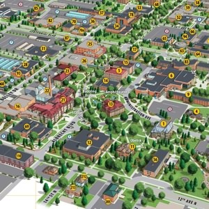
The key piece of information needed from our clients to effectively complete a 3D perspective campus mapping project are good, high-resolution (and reasonably current) oblique aerial photographs depicting at least 85-90+ percent of the property to be mapped from the same elevation and direction that our clients wish to see depicted in their finished campus maps. If our clients do not have access to reasonably-current oblique aerial photographs of their property, we can also arrange for these services with our aerial photography partners on their behalf. Costs will depend upon location and the amount of urgency required in completing a photo shoot. However, we have generally seen photography fees of between $750 and $1,000 US for a majority of the aerial photography work we have had done in the United States. In addition to oblique aerial photography, we also generally like to receive copies of a property's site plan, along with any previous examples of campus maps for the property that we can obtain, as that provides us access to a very efficient method of ensuring a very accurate finished-product. Site plans are usually available from an institution's Physical Plant, Facilities Department or Campus Architect. mapformation would also use several of its satellite imagery resources, as well as other mapping resources as reference.
That decision that is completely up to our clients. They can maintain the images themselves. They can hire mapformation to maintain the imagery for them. They can even hire a third party to maintain the maps for them if they so choose (though we hope that is not the case)! Our firm is obviously hoping that we will be able to develop long-term, fruitful relationships with all of our clients, and we enjoy having the opportunity to maintain the maps we have created in perpetuity! However, this is a decision that is completely up to our clients. Roughly half of our clients choose to have us maintain all aspects of the imagery we have developed, while 80-85 percent of our clients will have us perform at least "major" updates as changes occur. Specifically related to hand-rendered map artwork, the number of clients that choose to have us maintain their graphics for them is just-under one hundred percent.
Our firm will typically deliver finished artwork in SketchUp (.skp) format, as well as a variety of "2D" output formats that clients might desire, including .jpg, .tif, .eps, .pdf, .bmp, .png, .dxf and .dwg. The editable .skp file format would require that our clients have a copy of SketchUp in order to edit the map in three-dimensional form. Clients could, however, overlay information on top of any "static" views that are generated in 360-degrees by importing .tif, .bmp, .jpg or .png graphics into any raster software program, such as Adobe Photoshop or Corel PhotoPaint. Clients could also place copies of the finished work into AutoCAD to complete a variety of enhancements as well.
Our clients do, with two very important qualifications. First, the fees that have been mutually agreed upon by mapformation and our clients must be paid in-full before mapformation will officially turn over copyright to the completed artwork. We rarely have difficulty in having clients pay their invoices on time! However, the one bit of "protection" we build into every agreement for those few clients who do not pay their invoices in a timely manner is the fact that our clients do not officially own the work until it has been paid for in-full. The second important qualification relates to mapformation retaining the right to use copies of the artwork in effort to promote our services to prospective clients. We essentially are obtaining written authorization from our clients to utilize copies of the artwork in print and electronic form for self-promotional purposes when our clients agree to that type of terminology on our bids, estimates and contractual agreements. It's harmless language to our clients, but is VERY important to our firm...since the quality and depth of our portfolio is EVERYTHING when it comes to promoting our services to future clients.